")
Sandviksfjellet
Sandviksfjellet is located north of Fløyen and the city centre, and is popular for hiking and exercise.
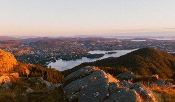
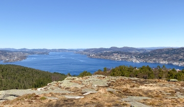
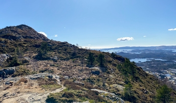
From Sandviksfjellet (417 m), you can enjoy one of the best views in Bergen. The view is of the city centre, the city fjord, the island of Askøy, and the other mountains surrounding Bergen. From Sandviksfjellet you have several hiking opportunities, including hiking to Rundemanen and Fløyen. In addition to hiking, you can swim in the lake on top of Sandviksfjellet, or hike further to reach mount Fløyen.
Facts about Sandviksfjellet
- Elevation: 417 meters
- Hike duration: 25-45 min (more if you expand the hike)
- Track: forest and footpath
- Difficulty level: easy/medium
The hikes up Sandviksfjellet
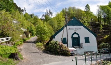
- If you want to go to Sandviksfjellet via Skredderdalen, you can start the ascent in Mulen next to a white building with the text Bergen Vandverk 1914. You follow the path all the way up to the start of a gravel road. Turn left and then left again up a short curve. On the top of the small hill, there is a path going towards a cairn. From here you have an excellent view of Bergen. Follow the road back or continue along the lake until you reach the end. Here you have several options for hikes.
- Another route includes the infamous and popular Stoltzekleiven. You walk around 800 steps towards the top. The reward is a beautiful view over Bergen and you can continue your hike towards Rundemanen. You can also join the Stolzekleiven Opp race, which is arranged every September in Bergen.
How to get to Sandviksfjellet
The two most popular paths to the top are the challenging Stoltzekleiven and the more moderate Skredderdalen. Both paths begin in Fjellveien.
- You can begin the hike by walking to the starting point Mulen, Skredderdalen or Stoltzekleiven from Byparken.
- If you need public transport, you can hop on almost every bus running in the northern direction from Festplassen, Torget (Fish market), or Bryggen to reduce your walking somewhat. By taking the bus you can start the hike almost right from one of the starting points. Search for the best transit options in the Skyss Travel Planner (you can also use the map available on their travel planner to find a bus stop close to the trail head you want to use). The closest bus stop to our suggested routes are Mulen or Munkebotn.
Parking close to Sandviksfjellet
- If you want to travel by car, it is easiest to park in one of the parking houses in the city centre. The Sandviken-area has few and mostly private parking spots.
Safe hiking in Norway
Stay safe and get the most out of hiking in the Norwegian nature.
Need to rent outdoor equipment?
There are places you can rent equipment for free or a small fee.