Where to run in Bergen
Bergen offers a variety of running routes that will suit both casual joggers and serious runners, often in areas with a scenic view. Take a look below for resources to local running routes, groups, and races.
Store Lungegårdsvannet
A pleasant and flat track around a lake. This path is a total of 4.5 km.
Getting there
You can easily walk or run to Store Lungegårdsvannet from the city centre. The Bystasjonen and Florida bybane stops are good places to begin or end your run.
The route
- One option is a route starting and ending at Bystasjonen, 5.1 km.
- Here is another route option including Nygårdsparken and Store Lungegårdsvannet, 4.5 km*
Fjellveien
Stretches 4,6 km from Amalie Skramsvei in Sandviken to Bellevue.
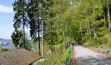
The Fjellveien path is mostly flat, with some easy hills. The path offers panoramic views over Bergen. Fjellveien is a favourite running route for many locals and is part of the Bergen City Marathon route. From Fjellveien you can access other trails that take you further up onto Fløyen, Sanviksfjellet, or Rundamanen.
How to get there
- To run/walk there, follow this route from Byparken. This is a nice way to warm up. Once you've reached the water fountain (called Hesten trenger hvile, or "horses need rest"), Fjellveien extends out both to the north and south. There will be a sign that indicates Fjellveien as well as routes up Fløyen.
- It is also possible to take the Fløibanen Funicular to the mid-station and walk to Fjellveien from there. However, not all departures stop at the mid-station so check with the front desk if you choose this option.
- If you need to use public transit to get into the city centre, search for best transit options on the Skyss Travel Planner. Input ‘Bergen Sentrum’ as your destination to get the most options for transit to the city centre.
The route
There are many options for where to start Fjellveien and you can walk as much or as little of it as you want. Here is a suggestion for a round trip route starting and ending a Byparken that includes most of the path, 8.4 km.
Tveitevannet
A small lake near Fantoft that offers a convenient short loop route.
Tveitevannet is a body of water between Løvstakken and Ulriken. There are footpaths hugging one side of the lake and a street running along the other side.
How to get there
- From Fantoft, Tveitevannet can be accessed by a short walk, run or the Lightrail.
- If you are not living at Fantoft, take the Lightrail to Sletten Senter and you find Tveitvannet just across the street.
The Route
- Here is a walking or running route from Fantoft around Tveitevannet, 3.3 km.
Other route options are found on running apps like Strava or MapMyRun.
Nordnes
The peninsula near the city centre. Nordnes Park is located at the tip.
A walk or run from the citycentre through the neighborhood of Nordnes to Nordnes park and back is a popular running/walking route.
How to get there
If you need to use public transit to get into the city centre, You can search for the best transit options for you on the Skyss Travel Planner. Using " Bergen Sentrum" will offer the largest number of options for routes to the centre.
The Route
- Click here for a walking or running route from Byparken to the tip of Nordnes and back, 3.4 km.
Løvstien
Løvstien is the newest addition to Bergens many hiking paths, and is a 6.3 km route that runs along Løvstakken mountain.
The Route
- From the city center, run past the University of Bergen and across Puddefjordsbroen towards Løvstakken.
- From Løvstakkveien 51 Løvstien starts.
- The path is part gravel, part wooden bridge and part tarmac
- If in need of transportation, you can check the Skyss Travel planner for Løvstakkveien.
- On sunny days, expect a lot of Bergen people out enjoying the weather and the view.
Gamlehaugen
Since 1925, Gamlehaugen and its surroundings have been a public park, museum and royal residence.
Gamlehaugen is a picturesque mansion that looks like a tiny palace and is located nex to the scenic banks of a fjord. In the summer time, the grounds of Gamlehaugen are popular for picnics and fjord swimming. You can read more about Gamlehaugen here.
How to get there
- From Fantoft, Gamlehaugen is a short walk or run.
- If you are not living at Fantoft, search the best transit options to the Fantoft bybane stop on the Skyss Travel Planner.
- You can also enter the Gamlehauvegen stop at your destination and walk or run from there.
The Route
- Click here for a walking or running route from Fantoft to Gamlehaugen, 1.6 km one-way.
More running options
Get social
- BSI Friluft has a Monday jogging group if you would like to be social and meet other runners.
Get competitive
If you are a dedicated runner, you may like to join a running event or race. Here are a few to get you started.
- Bergen Challenge: Bergen's Student Games, featuring a half-marathon (and many other sporting events). Read about the Bergen Challenge.
- Stolzekleiven Opp: An annual race up 800 uneven stone 'stairs'. Read about Stoltzekleiven Opp here or follow Stoltzekleiven Opp on Facebook.
- Ulriken Opp: A race up to the top of Mount Ulriken (605 metres) from ~200m. Read about Ulriken Opp or follow Ulriken Opp on Facebook.
- Fjordkraft Bergen City Marathon: A marathon, half-marathon, 5K and Relay Race. Read about Bergen City Marathon or follow Bergen City Marathon on Facebook.
- Bergen Fjellkarusell: 6 runs in Bergens many mountain areas. Check ut Bergen Fjellkarusell
- Bergen Fjellmarathon: A half-marathon in the mountains. Read about Bergen Fjellmarathon or follow Bergen Fjellmarathon on Facebook.
- Trolljeger (Troll Hunter): An 8k/obstacle course race. Read about Trolljeger
- The Great Fjord Run: 5K, 10K, and half-marathon options. Read about the Great Fjord Run
- For other options, see Kondis (the website of the Norwegian Association for Endurance Sports) or the site for BFG running club.
If you are interested in other routes, check out the Bergen running suggestions on Mapmyrun.
You can also check out the interactive map at UT.no to search for more route options in the city centre.This website is only available in Norwegian. In order to limit searches to running/walking/hiking trips, select Turforslag (tour suggestions) and Sommerstier (summer trails). Under Turforslag, enter Vestlandet and under Type tur (Type of tour) enter Fottur (Tours on foot). Under varighet, you can select the length of tour: Dagstur (day tour) by timer (hours) or Flere dager (2 or more days). You will also have to zoom in on Bergen in order to search for routes via the map.
NB: When using Norwegian-only resources like UT.no, view the map directly instead of relying on browser translation. Translate text as needed, but leave place names as they are — this keeps trail and transit names accurate and easy to navigate by.